










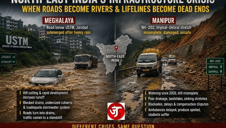
From the flooded road beneath the University of Science and Technology Meghalaya to the battered Imphal–Ukhrul highway in Manipur, two very different images are telling the same story. The North-East is building. But is it building the infrastructure needed to survive what it is building?
The Jorabat–Khanapara corridor has repeatedly suffered serious waterlogging during intense rain. Reports from the area describe roads being submerged, vehicles stranded and traffic virtually paralysed.
The geography makes the problem particularly serious. USTM sits in the Baridua/Kiling Road area of Ri-Bhoi, Meghalaya, on elevated terrain above the Assam side of the border.
When enormous quantities of rain fall on the hills, water naturally seeks the lowest ground. Development changes that equation. Roads, buildings, paved surfaces, earth-cut slopes and altered drainage channels can accelerate runoff and send larger volumes of water downhill in shorter periods.
And this is precisely where the controversy surrounding USTM becomes important.
Why is USTM being blamed?
The Assam government has repeatedly argued that large-scale hill cutting and development around USTM and the wider Jorabat area have increased runoff flowing towards Guwahati. More recently, Chief Minister Himanta Biswa Sarma said a Supreme Court-appointed committee had examined the issue and warned about environmental consequences from continued development around the USTM-Jorabat belt.
But there is an important qualification.
“It would be inaccurate to say that USTM alone causes the flooding.”
The problem involves the entire Jorabat-Khanapara drainage basin, including development, hill cutting, blocked or undersized culverts, road design, natural drainage channels and Guwahati’s downstream drainage limitations. Local reporting has specifically identified blocked culvert exits and inadequate drainage as major contributors to recurring flooding.
USTM itself has previously argued that its campus contains five large natural reservoirs and that its contribution is only a small part of the total water flowing down the Kiling Road drainage network.
“If a university of this scale has been constructed on a major hill system above a densely travelled road, the obvious engineering question is: Where is the stormwater management system capable of handling extreme rainfall?“
That does not necessarily mean there are literally no drains. There are drainage channels and culverts in the wider area. The problem is whether the entire drainage network is adequately sized, connected, maintained and designed for today’s runoff, rather than for some older landscape that existed before extensive construction.
That last part matters enormously in Meghalaya and Assam. A drainage system designed for yesterday’s rainfall can become almost decorative when confronted with today’s cloudburst.
TThe road below USTM is effectively at the receiving end of water coming down from higher ground. If the drainage system cannot carry that water away quickly enough, the road becomes the drainage channel. In reality, a large part of the water may be runoff arriving from surrounding slopes and upstream catchments, combined with water falling directly on the road.
Jorabat;s problem is an old well-documented one. Recent reporting describes the area as repeatedly flooding during intense rainfall and points to inadequate drainage and blocked culverts.
“If this enormous university and the surrounding hills have been extensively developed, where is the integrated stormwater infrastructure designed to safely carry the water generated by that development?”
That is a legitimate engineering and public-safety question. And when the road below a major university turns into a river during heavy rain, “it rained heavily” is not a sufficient infrastructure explanation. Heavy rain is a natural event. Turning it into a recurring transport disaster is partly a question of planning, drainage capacity and maintenance.
For today specifically, the IMD is warning of continued heavy rainfall in Meghalaya, with very heavy rain possible on August 30, so this isn’t merely an academic argument about drainage.
The complaint about NH-202 is not new, and it is not just rhetoric. The Imphal–Ukhrul stretch has been a slow-motion failure for years: widening that began around 2020 with a 20-month target is still incomplete in 2026 on key packages, with unfinished blacktopping, missing drains, sinking stretches, and frequent landslides.
Villagers along Finch Corner–Choithar have repeatedly threatened or imposed blockades over unpaid compensation and stalled Packages 3 and 4 even after land acquisition. Ethnic blockades layered on top of that, Tangkhul restrictions at places like Wunghon, Kuki counter-blockades, and security incidents, have made the road even less reliable. The result matches what you listed: ambulances delayed on a route that is the main medical lifeline for Ukhrul and Kamjong, perishable produce spoiled before it reaches markets, and students grinding through hours of potholes to reach Imphal.
“Double engine” governments have announced large NH packages, Bharatmala corridors, and completion dates that keep slipping. Some work is happening on the Yaingangpokpi–Finch Corner sections and later packages toward Jessami, and blockades were lifted in mid-August 2026 after government assurances of free movement. That does not erase the years of neglect or the daily cost to people who live along the highway.
Infrastructure failure here is both a governance problem (compensation delays, contractor performance, maintenance after monsoons) and a conflict problem (highways used as leverage). Treating only one side of that equation leaves the same muddy road.
JANPATH NEWS NETWORK (JNN)
Independent. Fearless. On the People’s Path.